Planning and optimization
Shuttle network and line planning
Employee addresses, stops, lines and campuses on a single map. Instantly see who is outside coverage, where seats sit empty and where walking distances are too long.
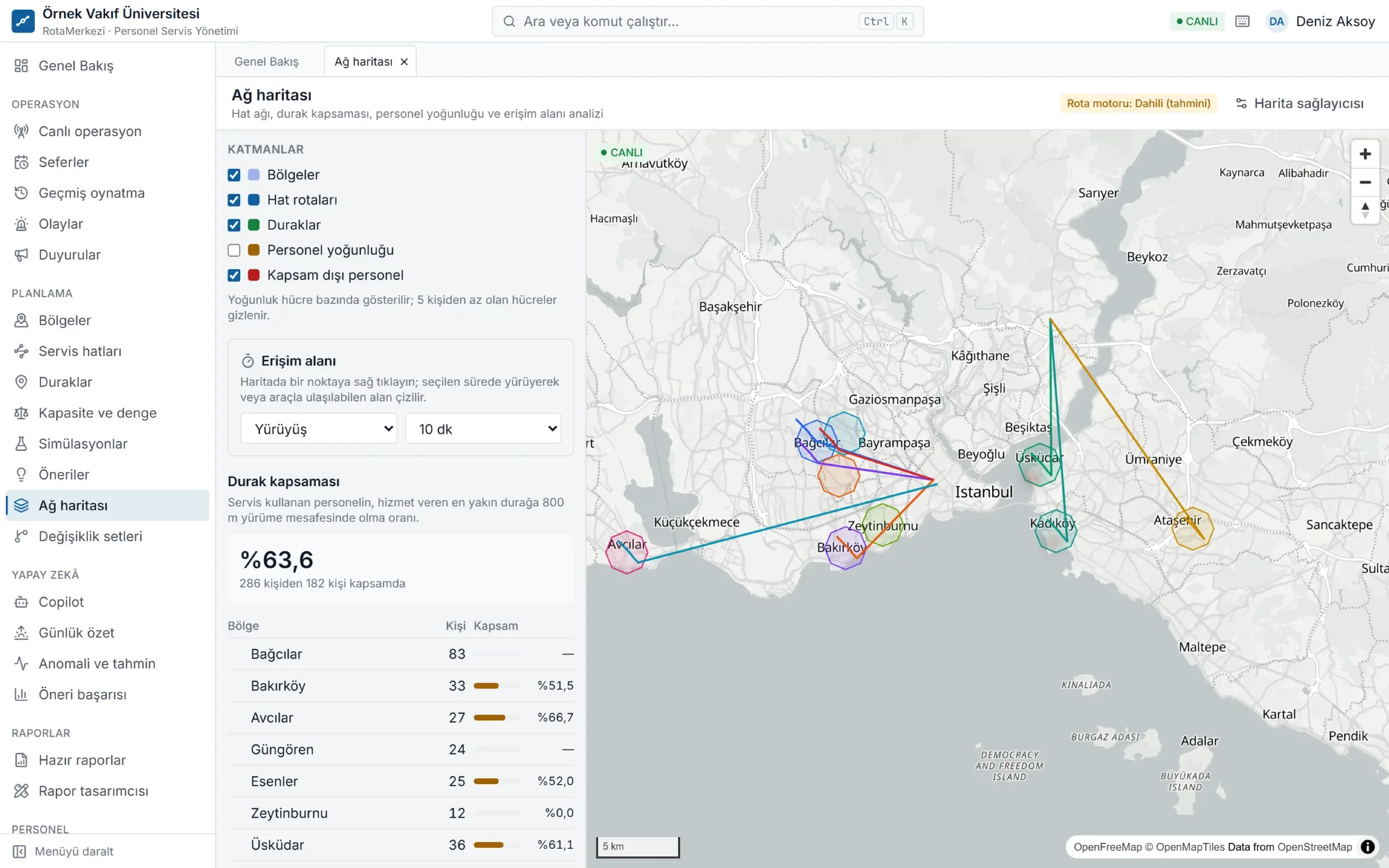
Your entire shuttle network on one screen
RotaMerkezi shows your organization's shuttle network on a map, layer by layer: employee density, stops, lines, campuses and regions. At a glance you can see which employee walks to which stop, and which line runs at what time with which vehicle.
The network map runs on server-generated vector tiles, so it stays smooth even for organizations with thousands of stops and employee addresses. Every layer is tied to the user's permissions: even a user who can see employee density cannot see individual home addresses, only anonymous density cells.
No blind spots in planning
- Coverage analysis: Employees outside the walking distance you set are listed on a separate map layer.
- Occupancy: Each line's capacity is calculated from its vehicle type; overcrowded or half-empty lines trigger warnings.
- Line versions: Route and stop changes are prepared as draft versions and take effect on a set date once approved. Past versions are retained.
- Regions and campuses: In multi-campus organizations the network is managed by region; users see only the regions they are authorized for.
Lines, versions and trips
In RotaMerkezi, a line (e.g. "Bağcılar – Main Campus") consists of versions that change over time. Each version has its own morning and evening schedule, stop sequence and departure times. Daily trips are generated automatically from the version in effect, taking the shift calendar and public holidays into account.
This separation means:
- You can prepare today a route change that takes effect next month; the live line is unaffected.
- You can look back at which stops a line used to serve, who was registered on it and which vehicle was assigned.
- A vehicle or driver change can be applied to that day's trip only, without disrupting the line's plan.
Stops and catchment areas
Stops are shared between lines. You add a new stop by right-clicking on the map and move a stop by dragging it; moving requires confirmation and is written to the audit log. Every stop has an arrival radius; when a vehicle enters this area, live tracking counts it as "arrived at stop".
Right-click on the map to calculate a catchment area (isochrone): the area reachable from a point within a 5–30 minute walk or drive, shown together with the number of stops and the anonymous number of employees within it. Stop coverage by region measures what share of employees using the shuttle are within walking distance of their nearest stop.
Who is it for?
Any organization that plans its shuttles with Excel spreadsheets and experience, and updates lines by hand every time an employee joins or changes address. In particular:
- Hospitals and universities with multiple campuses and shifts
- Factories and organized industrial zones with high staff turnover
- Public institutions that manage their shuttle network together with vendor companies
Frequently asked questions
What data do I need for shuttle network planning?
An employee list with addresses (or locations), plus campus and shift information, is enough. Existing stops and lines are imported if you have them; if not, they can be designed from scratch on the map. Addresses are converted to locations, and records whose location remains unclear are listed for correction.
Are employees' home addresses visible to everyone on the map?
No. By default the map shows only anonymous density cells, and cells with few people are hidden. Full addresses and exact locations are revealed only to authorized users, through a separate request, and every view is written to the access log.
When does a line change take effect?
The change is prepared as a draft version and, once approved, takes effect on the date you choose. Trips generated from that date onward use the new route; the previous version is kept in the history.
Can each unit manage its own network in a multi-campus organization?
Yes. Users are assigned a unit or region scope; each user sees and manages only the employees, lines and trips within their own scope.